Tuesday, October 27, 2015

River Dunes mm 174, to St. Augustine Municipal Moorings, mile marker 776.8

First thing, I always do the morning "walk" with Mazu.  Today, Mazu's last fun run before 3 days at sea.  She seems to know it.  The big empty lot behind the resort is perfect for sniffing and exploring.  There's also a high platform to look out over the marsh.


Saturday, October 24-27
Chores before we can go offshore for 3 days.  The decision was made based on all of the weather reports from multiple sources.  "nice," "no problem" were the words used for a passage on the Atlantic at this time.  We aren't interested in an uncomfortable ride or getting banged up reaching for hand-holds and missing when the boat lurches.

   Zipper lubed all the zippers on the enclosure - makes a big difference when you're outside.  No need to fight with the zipper.  Filled up on fuel and water.


The black thing next to Drew is the engine we took off the dinghy and lifted up to the rail of the cockpit.  You see Drew putting back the "crane" lines that lifted up the outboard.  Hauling up the dinghy is the beginning to Drew's non-stop day.  This arrangement allows for less strain on the dinghy if there is a bumpy ride on the Atlantic.  Triple pulleys for the dingy make it easier to haul it up on the davits.
Other chores: make tuna salad, have finger food list by the stove for easy access if the seas get too lumpy and make it hard to cook.  Secure everything so it doesn't fall.

The forecast: sunny, calm, winds going to a maximum of 20 K from the north, waves 2 to 4'.  All looks and sounds good.  You can see how calm the water is in the above picture in this hurricane hole River Dunes marina - very safe.
  We left at 10 am.  I cooked breakfast on the way to Morehead City, NC from River Dunes (near Oriental, NC), a 5 hour trip.  From there we head out to the Atlantic where we are incommunicado for 3 full days.
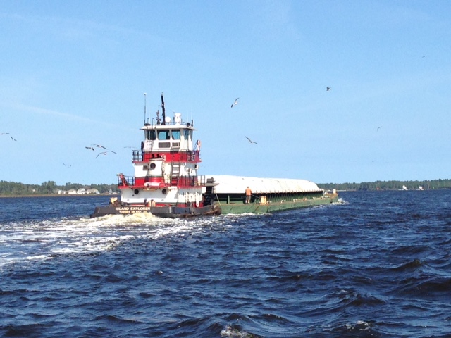
  This is the typical size of the barges, and we need to move out of the way!  Needless to say they have right-of-way. 


You can see more of chop on the water this gorgeous day.  Wind is picking up.
The forecast said winds 15 to 20 with seas at 2' to 4.'

 Sailing wing and wing when the wind is directly behind the boat.
 Harness on at all times as the wind begins to pick up.  The harnesses allow us to hook onto the jack lines that are attached from the bow to the stern for off shore sailing.  When we hook in we are attached to the boat essentially. The jackets inflate when/if we fall overboard.  There is also a manual button if they don't inflate.  We also attached a whistle.  It can be impossible to see the person in the water if they are down in the trough of the waves.  There's a button on the Nav station at the helm for MOB, man overboard, to mark the spot.  Safety, safety.  When I run a MOB situation through my mind I release the life Sling, throw tons of floating stuff in the water hoping the MOB can swim to something: life saver, cockpit cushions, other life preservers.  Fortunately the water is warm here and hypothermia is not as apt to happen.
Saturday was nice and pretty calm.  We stuck a couple of Weight Watcher "TV" dinners, Salisbury steaks, in the microwave and ate with the usual sunset entertainment.

Here are the instruments at night.  We try to have as little light on as possible so our night vision isn't compromised.
The top shows our track based on a 360 degree compass, 2nd window shows the depth at 103,' the speed isn't working on this instrument - we see speed on radar and Navionics, after speed is the water temperature at 75 F, and the last gauge is where the wind is coming from - here it's 110 degrees from the northeast or starboard side. 


The image below isn't clear, but this is the Navionics tracking and shows the speed on the Ipad.  The orange rectangle is the VHF radio that is always on and rotating channels 9, 16 and 13.  This is the ship to ship or ship to shore communication line within 10 miles or more.  Everyone can hear anything said on VHF.  Occasionally there is an argument when a power boat passes a sailboat.  The giant wake can cause a lot of rocking for a sailboat so if they are polite the power boat will tell you on VHF that they are coming by slowly, "a slow pass."  Today, one guy gets on the radio and yells at a power boat captain, "The river is 5 miles wide here, you a###, and you pass 100' by my boat.  I'm a sailboat.  Sailboats have the right of way.  What are you doing?"  And the power boat guy just answers in a calm voice, "Keep it in New Jersey."  It was pretty funny.   Rarely do you hear that kind of interchange because there are strict rules about being polite on VHF.


These three dials show the RPMs, here about 2300, the oil gauge, and the temperature of the engine.

This is the floating dial compass.  The line at the top indicates our heading at about 225 degrees.  You can see 0 is north.

 The radar screen is really important when we are moving at night.  Our boat is in the center and the concentric rings show how far away a dot (boat) is from our boat.  Big huge ocean but there are an amazing number of times the course has to be altered to accommodate the other boat's right of way.  We can set the radar range to show what's out there as far away as 48 miles.  We usually run with it on 12 miles.  Remember we are traveling at 6 k which is about the speed of a jogger. The data boxes on the bottom automatically tell, how long to the next way point, speed, track heading, lat and longitude, error if we don't follow the track.


SUNDAY at the helm.
  
 Early morning at the helm: ship's log on the seat and plenty of water bottles. Ipad Navionics is on the right.  Nice to have a full enclosure  -a little sunroom.  56 degrees in the morning but it warmed up to 77 F.
 Still the wind is at our back, and we are sailing wing and wing with the early sun through the 3 sails.
Winds pick up.  Here is Drew to explain.
Monday:  We were pretty disappointed in NOAAs prediction and everyone else who said the rain and winds weren't coming until Wednesday.  Au contraire, we got caught in a couple of squalls.
In the middle of the day the topping lift snapped off the boom and was just hanging down over the water.  The shackle probably broke. We used the boat hook to pull the line in and attach it to a spare halyard.  This means that later I will need to go up the mast (love to do this) to reattach a new shackle to the correct line that's loose at the top of the mast.  The topping lift is the line from the top of the mast to the end of the boom.  It holds up the end of the boom when the sail is not out. 

Mazu and I stayed in the well padded aft cabin bed, the place on the boat with the least motion.  Poor Mazu, she fortunately peed on the bow twice during the trip but still so anxious.  I gave her half a Benadryl in spite of these words on the package, "Marked drowsiness may occur. DO NOT USE to make a child sleepy."  It's the first thing I've used that's put a dent in her anxiety and let her relax a little.  The vet had used it on her when they took a blood sample so I knew it wouldn't be harmful.  Mazu has always had a small bump cyst on her leg, but recently it's grown bigger so when we return to Exeter the vet will remove it surgically and get a biopsy.

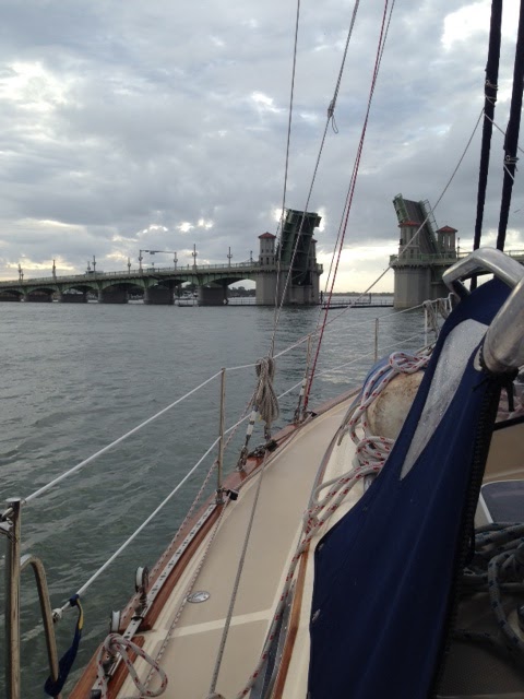
As we neared the St. Augustine inlet Tuesday morning at 7:45 we called Tow Boat US to get "local knowledge" about the passage through.  Inlets are subject to shoaling and change often.  They didn't answer so we called the Municipal Marina here and asked them. She passed it onto the Coast Guard because they just happened to be around the Marina.  Instead of talking us through they came out and gave us an escort through the pass in their little red ribbed inflatable.  We rounded the corner and waited with 6 other boats, just 10 minutes for the Lion's Bridge to open.


Yay , we made it to the mooring 8:45 am.  The launch came out at 10.  With excited Mazu we registered the boat, got keys/card for the facilities, and had a cup of coffee/latte at the wonderful hotel opposite beautiful Flagler College.  I had heard they have tours of this amazing building that used to be the Flagler Hotel when Mr. Flagler was making tons of money bringing the railroad to Florida and developing the state.  I'll tour tomorrow and send pix.
Here is the courtyard.


All in all it was hard trip with inaccurate weather information.  The wind went to 40 mph Monday night with large waves and lots of rocking and rolling.  I had on my transderm patch so no sickness from any of us.  We'll be here for a few days before we rent a car to drive north for meetings in New Hampshire.
  We're on the boat this afternoon while the raindrops tap dance on the canvas and clear the boat of all the salt water.  Drew and Mazu were awake most of the time during 3 days travel.  Drew because he was concerned about the weather and Mazu because she was anxious about the boat travel, almost constantly panting until the Benadryl kicked in.  Now they both collapsed to catch up on sleep.

We traveled 474 miles off shore with 12 hours of sailing without the motor.  Via the ICW with the same destination it's 602 miles. Via the Atlantic Ocean we saved time, gas, and headaches through the ICW trouble spots.  We missed the beauty of seeing the south close up.  Another time. 
Our destination is Coconut Grove, FL, Dinner Key Marina mooring field; the ICW mile marker is 1,094.

Friday, October 23, 2015

Belhaven, NC anchorage to River Dunes - a top marina in North America Mile Marker 173

Looking north from Belhaven, NC anchorage at dawn today.  Still still as stone and glossy as shiny paper.   We continued south through several more canals. At the Mayo fish processing plant we passed these two fishing boats with all their rigging.


This is our third year motoring south.  What a difference!!  We pass over 5' 8" and I hardly flinch because I know we're not going to get stuck on the mud. We draw 4' 7" that means our boat goes down 4' 7" from the surface of the water. The first year I was white knuckling every shallow spot, worried and anxious all the time.  Now I trust the boat and our careful tracking.  With redundant navigation tools: paper charts, Navionics on ipad, a depth sounder, Raytheon's radar at the helm, Active Captain reporting, a quick informational call to Tow Boat US when needed and most important of all our own eyes we avoid hazards all around us.  Yesterday three times I looked up and steered around an unforeseen:
1) stump in the middle of the channel,
2) partly submerged odd square object
3) random 4' stick pointing up out of the water
You never know.  Be alert.  When motoring outside we're avoiding huge barges and container ships. Inside the ICW it's little stuff that can cause big damage to the engine or hull.
At Alligator River Marina a guy next to us donned his wet suit to dive in and look underwater at his prop that had stopped working.  He bobbed up, and next thing we see him fixing his dinghy engine to his boat to use temporarily.

We are inside of land in fresh water opposite Cape Hatteras, NC where the beautiful Outer Banks are home to many a vacationer and where death has happened to many a ship that has tried to round one of the most dangerous areas of the seas.
 I will quote from Mark and Diana Doyle's On the Water ChartGuides.
Mason-Dixon Line of the Marine World:  We are south of the Mason-Dixon line but we just crossed he imaginary line called "the Mason-Dixon line of the marine world" by environmentalist and science writer Rachel Carson in her first book, The Edge of the Sea, a book about the estuaries surrounding Beaufort, NC. Rachel Carson was the scientist who later wrote about DDT and its close association with the near extinction of animal species that ingested it in her landmark book,  Silent Spring.
  Across Pamlico Sound, Cape Hatteras juts into the Atlantic.  The Labrador Current flows from the north, the Gulf Stream flows from the south.  The two currents converge at Hatteras, dividing the marine species into "northerners" and "southerners": cold-water species like cod, mackerel, and pollock to the north and warm-water species like Spanish mackerel, mullet and grouper to the south.

 Today's discussion: Should we push further south to Morehead City and out to sea for 3 days or stay in River Dunes?  We studied the weather and since there was a question we played it safe and stayed here.  We will read the weather updates in the morning and decide whether to stay in the ICW or go out to sea.  It takes 5 hours to get to the Beaufort City inlet at Cape Lookout --we'll study it then.
  Tonight we stayed here, one of the nicest marinas in America.


 stairway up the dinning room
 a unique chess set of labs as pawns and funny dressed up ducks as chess pieces.
A "private"dinner at the restaurant (we were the only ones there) with Claudette and Bruce from "Summer Wind." Mainers and New Hampshirites.  Feels good to be south in warm weather.
 

Alligator River Marina to Belhaven anchorage

Started at sunrise 7:15, actually earlier walking/running Mazu.  You can see the mirror smooth water.


So calm it's breathtaking.  The tree lined horizon is the center of the reflection of sky to sea.


I can skate across this sea, flat and smooth as ice.  Glossy, glassy, still as stone and smooth as glass.  Touching it makes a light ripple slide across.  There are 5 sailboats ahead of us going about 6.2 knots but far enough ahead that the ripples have smoothed out like smoothing a blanket free of folds.  I don't think I've seen such a broad expanse so calm, the Alligator River canal connected to the Pungo River, so still.  Motoring weather for sure.

Tonight we lie in the Belhaven anchorage at G 11, i.e. a green marker with an 11 on it with 9.5 feet of water under us between two 3' shoals.  We'll dinghy in to give Mazu a run and then dinner.
We were looking out the window while we ate at The Tavern at Jack's Neck in Belhaven.
 
Just read  Light in the Forest and Euphoria, and now Bryson's  A Walk in the Woods laugh-out-loud funny. I have to read parts aloud to Drew.


Wednesday, October 21, 2015

Goat Island Anchorage NC to Miss Wanda mile marker 84

Moving right along south with the calm weather.  I understand New England is having a glorious Indian summer - cool with beautiful colored trees. Threats, but no real snow yet.  We can see the temperatures in different cities and are glad to be in 70 degrees during the day.
  Last night we did dinghy in to the camping dock.

It was a board walk over the swamp and Mazu jumped down into the mud anyway, though it was a high jump back up.  She got a shampoo out of the adventure.
  Shawnee at dusk


Awoke to mist on the water, a few bird calls, and glassy water.  Sleeping weather but we were off by 8:45 toward Elizabeth City. Now in North Carolina.


  A Mazu update:  She takes herself to the aft cabin now for comfort.  Still panting, but less shaking. She came up on the bow herself this morning and "did everything" as we say.  Easy to wash down and throw overboard.  Our 3rd time south, and I think routines are falling into place.
No sailing, but I'm resigned to that and looking forward to sailing my paddle board.  I'd rather go over Albemarle Sound in the calm than in the choppy waters of the past.  No need for the transderm patch for seasickness.
  Going through the Elizabeth City Bridge with construction all around and some delays.
 You can see the left side of the bridge is still down and there is a construction barge in the way on the far side.  The left side went up in time and the barge moved.

 We continued through the day down the Posquotank River.  Another nice thing about the swamp is that there is no need for red and green buoys, markers or nav aids.  It is just the natural landscape.  So pretty.
Out of the swamp and down the river.  This is the US Coast Guard Rescue Training station where they faked that it was an Alaska - named it Kodiak- station for rescue training used in the movie "The Guardian" with Kevin Costner.  They made fake snow for the winter scenes.

We arrived at Alligator River Marina at 3:00.  It's the place where Miss Wanda let us leave our boat (against rules) and drove us to the airport last year when Rhona was so sick.  We flew up to see her in Albany before she died in November. 
     This marina can be sucked dry or flooded when there is a hurricane since the tides are wind driven.  The channel is 5 muddy feet deep to get into the slips.  There are about 16 slips, fuel and dockside tie-ups.  Besides anchorages it is the last stop before the Alligator River Sanctuary where there are no services for many miles.

Miss Wanda's home on the ICW
 little fake lighthouse
 Gas station where they serve dinner and breakfast.  Mazu was very happy to run free.

Still have Belhaven, River Dunes, Moorehead City until the ocean crossing to Florida.
I want to remind myself about a tip a fellow sailor told me about:  Brookgreen Gardens in Myrtle Beach, SC a remarkable sculpture garden that I am dying to see, but may need to do it by car.


Tuesday, October 20, 2015

North Street Basin, Portsmouth, VA to Goat Island, Elizabeth City, VA

What a fiasco with a limited opening Railroad lift bridge.  Openings are only 9, 12, and 3 each day for a week of construction.  The crowd of about 35 boats awaited the 9:00 am opening.  The season of boats going south has been delayed a bit because of Hurricane Joaquim coming through, rainstorm floods, and this bridge construction.  Some have said it's caused crowded marinas and anchorages.  We'll just have to see today.


We had good eats to start this motoring day --muffins right out of the oven.

 with close to no wind, sunny skies and 61 degrees.  We left the Navy at Norfolk. Always feel some pride seeing those huge ships.

Everyone was pretty bundled up for a day going south on the ICW.  We turned for the Dismal Swamp, a canal authorized by General George Washington.  It has a sketchy history of starting with slaves digging and constantly near bankruptcy until the Army Corps of Engineers and the Federal government stepped up to maintain it.  It allows boats to move safely south out of the ocean inside of Cape Hatteras.  The canal originally was to help commerce move up and down the coast.  Now it helps the economy of several old towns struggling to stay relevant with historic tourist attractions and cute restaurants.
The Dismal Swamp is much narrower, shallower and more beautiful.  Without commercial traffic and fewer boats in general wildlife abounds -- turtles on logs, herons flying from limb to limb, Vs of geese flying or paddling in the water.  We saw vistas of farm land and homes through the narrow strip of bordering trees, a bucolic scene.  The experienced say boat captains must look up as masts may rip through trees (we did) as well as look down to the shallow depths.  But even when the depth sounder read low numbers the soft mud was easy to drive through.  The Dismal Swamp Canal parallels the Virginia Cut Canal with a couple of extra miles.  I am so glad to explore a new place.

We entered Deep Creek Lock at mile marker 10 at 10:30am -- cozy with 11 boats.  We are to the left with the solar panels on top of the bimini.  We didn't exit until 12 noon.
Tied to the wall as the water came up.

Added personal Graffiti on the lock wall.

Conch shells surround the Lock House.   The lock master played his conch and called mine a helmet conch.  He taught me how to play it, change notes, trill.  I have work to do.  We shared a couple of sticky buns with him.
First of all I was holding it wrong.  As my fingers get deeper into the shell the tone will go lower.  Cool.  I can also learn to trill my tongue as I play.

With absolutely no wind it was perfect to be a motor sailor.  The reflection is pristine.


We discussed whether we should go all the way to Elizabeth City and get a free slip or anchor at Goat Island.  I figured there have to be very few boats ahead of us because we and one other boat were the only ones today who went through two locks and passed the bridges without delay.  We traveled 6 k so we could make it through and get this far.  There isn't any reason or place to stop except a few side docks near the locks and Elizabeth City on the Dismal Swamp - it's the experience.  When we arrived at Goat Island Anchorage, mile marker 43, we found it empty --  it was too nice to pass up so we anchored.  Today we traveled on the water from 8 to 6pm covering 36 miles.  Lots of stars to see tonight with no town lights.

For dinner Drew put the frozen steak on the engine to defrost.  I cooked chicken with onions on top of salad. 
 In a protected anchorage behind Goat Island  watching the sunset with its reflection in the water.  Perfect day.
I bit the bullet and decided to buy CBS.com all access for $6 a month and listened to the live news. CBS has the shows we watch, Madame Secretary, NCIS, and The Good Wife.  So far this has been our most comfortable passage with far fewer projects and all in working order.  Thank you Zimmerman Marine.